Wawa Points of Interest (2013)
We were in the Wawa area once again on the final leg of a four day Breeding Bird Survey that Gerhard and I undertake for Environment Canada. Compared to the dry conditions of a year earlier, Wawa was now trying to cope with the high water levels caused by late Fall rains, heavy winter snowfalls, and a late Spring.
Last year we had spent the night at the Northern Lights Motel as an alternative to staying at Opanango Provincial Park. This year, staying at this motel was not an option since they were still in the process of recovering from a huge flood and highway washout that occurred in October 2012. The photos below were taken June 2013.


 Â
 

For a look at a wonderful collection of photos of this disaster scene in the Fall of 2012, take a look at the motel’s website collection of images here: Northern Lights Motel flood images and highway washout. The aerial shots are especially spectacular.
In 2012, I took a number of photos of some of Wawa’s primary sights of interest from a tourist perspective. Getting to some of those sites this Spring was a bit of a challenge since bridges in the area were still closed and some roads were still being reconstructed from washouts. Both Silver Falls and Magpie High Falls were showing drastically higher flow rates that in the Spring of 2012 and the waters of Lake Superior were very calm at Government Dock Beach.
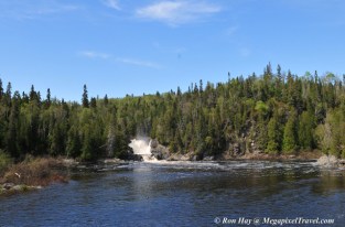
Magpie High Falls (2013) (link to 2012 for comparison)

 Â
 
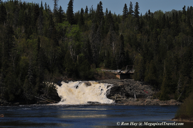
Silver Falls (2013) (link to 2012 for comparison)
This year, we had to walk to Silver Falls since the roadway was closed to vehicular traffic. As we came in site of the area beneath the falls it was immediately obvious that water levels were higher than the previous Spring since one of the locations where I had stood to take photos in 2012 was now under many feet of fast moving, swirling water and looking down over the lower falls section we could not see the rocks upon which we had stood the previous Spring.


The lower falls as taken from the local village of Michipicoten which had also been isolated by the various road washouts over the past 6 months.
 Â
 
Government Dock Beach (2013) (link to 2012 for comparison)
In 2012, the water flowing over the falls might have been more subdued but the lake waters pounding onto Government Dock Beach were nothing close to calm. This year the reverse held true as the waters of Lake Superior were quite calm.


Last year, in our travels we saw plenty of rabbits darting out onto the roads. This year we saw plenty of hawks and foxes.

This year, we finished off our day at the enjoyable Wawa Motor Inn under the watchful care of one of Wawa’s three large Goose statues (more WAWA goose statue information)

